Pelican Parts
Parts Catalog Accessories Catalog How To Articles Tech Forums
Call Pelican Parts at 888-280-7799
Shopping Cart Cart | Project List | Order Status | Help


Go Back   Pelican Parts Forums > Miscellaneous and Off Topic Forums > Off Topic Discussions


Reply
 
LinkBack Thread Tools
Author
Thread Post New Thread    Reply
Back in the saddle again
 
masraum's Avatar
 
Join Date: Oct 2001
Location: Central TX west of Houston
Posts: 56,631
St Francis Dam collapse

I think I may have read a mention about this at some point while reading online about Mulholland, but I don't think that it was much more than a brief mention. Based on Jeff Hail's comments in that thread, I've read up a bit on it, mostly what's on wikipedia, although I have some other stuff queued up to read. It was very interesting. The power of mother nature is impressive.

THe interesting thing is that I read about it the other day, and then that evening or the next day my wife said "Let's watch 'Chinatown'" which loosely/fictionally references the people and things involved. I've read a history of the Seattle area called "Sons of the Profits" (yes, spelled like that), and the story (real and fictional) somewhat reminded me of the vibe from the book.

Now I'm curious to read even more about the St Francis Dam and Mulholland.

Some Amazing stuff.
(excerpts from https://en.wikipedia.org/wiki/St._Francis_Dam
Quote:
he dam was designed and built between 1924 and 1926 by the Los Angeles Department of Water and Power, then named the Bureau of Water Works and Supply. The department was under the direction of its general manager and chief engineer, William Mulholland.

At 11:57 p.m. on March 12, 1928, the dam catastrophically failed, and the resulting flood took the lives of an estimated 431 people at least.[2][3] The collapse of the St. Francis Dam is considered to be one of the worst American civil engineering disasters of the 20th century and remains the second-greatest loss of life in California's history, after the 1906 San Francisco earthquake and fire.

Given the known height of the flood wave, and that within seventy minutes or less after the collapse the reservoir was virtually empty, the failure must have been sudden and complete. Seconds after it began, little of what had been the dam remained standing, other than the center section and wing wall. The main dam, from west of the center section to the wing wall abutment atop the hillside, broke into several large pieces, and numerous smaller pieces. All of these were washed downstream as 12.4 billion gallons (47 million m³) of water began surging down San Francisquito Canyon. The largest piece, weighing approximately 10,000 tons (9,000 metric tons) was found about three-quarters of a mile (1.2 km) below the dam site.[47]

Five minutes after the collapse, the then 120-foot-high (37 m) flood wave had traveled one and one-half miles (2.4 km) at an average speed of 18 miles per hour (29 km/h), destroying the heavy concrete Powerhouse No. 2 there and taking the lives of 64 of the 67 workmen and their families who lived nearby. This cut power to much of Los Angeles and the San Fernando Valley. It was quickly restored via tie-lines with Southern California Edison Company, but as the floodwater entered the Santa Clara riverbed it overflowed the river's banks, flooding parts of present-day Valencia and Newhall. At about 12:40 a.m. Southern California Edison's two main lines into the city were destroyed by the flooding, re-darkening the areas that had earlier lost power, and spreading the outage to other areas served by Southern California Edison. Nonetheless power to most of the areas not flooded was restored with power from Edison's Long Beach steam electric generating plant.[49]

Near 1:00 a.m. the mass of water, then 55 ft (17 m) high,[50] followed the river bed west and demolished Edison's Saugus substation, cutting power to the entire Santa Clara River Valley and parts of Ventura and Oxnard. At least four miles of the state's main north–south highway was under water and the town of Castaic Junction was being washed away.[51]

The flood entered the Santa Clarita valley at 12 mph (19 km/h). Approximately five miles downstream, near the Ventura–Los Angeles county line, a temporary construction camp the Edison Company had set up for its 150-man crew on the flats of the river bank was hit. In the confusion, Edison personnel had been unable to issue a warning and 84 workers perished.[52]

Shortly before 1:30 a.m., a Santa Clara River Valley telephone operator learned from the Pacific Long Distance Telephone Company that the dam had failed. She called a California Highway Patrol officer, then began calling the homes of those in danger. The CHP officer went from door to door warning residents about the imminent flood. At the same time, a deputy sheriff drove up the river valley, toward the flood, with his siren blaring, until he had to stop at Fillmore.[44]

The flood heavily damaged the towns of Fillmore, Bardsdale, and Santa Paula, before emptying both victims and debris into the Pacific Ocean 54 miles (87 km) downstream south of Ventura at what is now the West Montalvo Oil Field around 5:30 a.m., at which point the wave was almost two miles (3 km) wide and still traveling at 6 mph (9.7 km/h). Bodies were recovered as far south as the Mexican border; many were never found

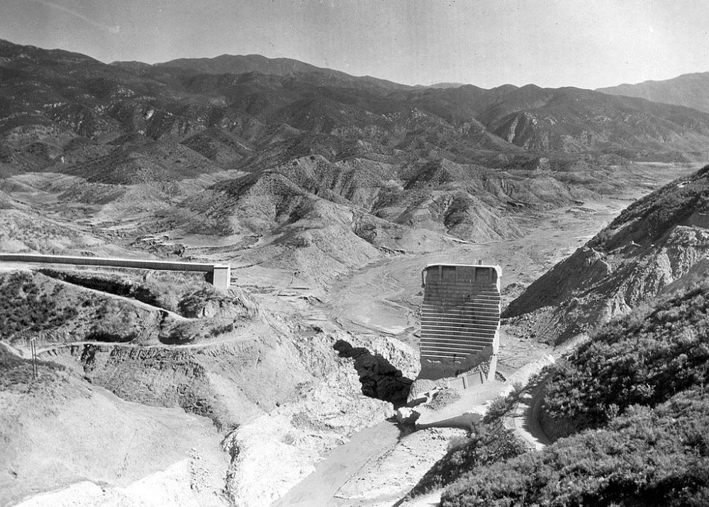
When you consider that there's a person standing on the ground at the bottom right of this photo, wow!


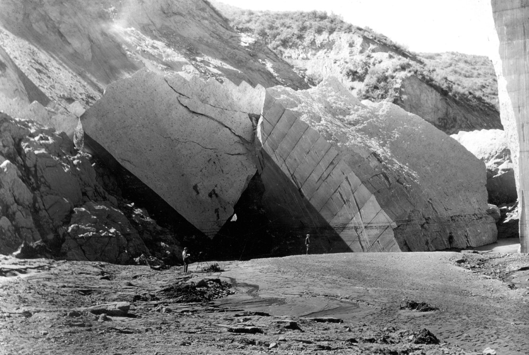
This is the piece that was found 3/4 mile downstream.

Quote:
March 15, 1928: A giant piece of concrete from the St. Francis Dam that was carried about three-quarters of a mile downstream dwarfs a man standing at lower right. Los Angeles Times
I want to say that I'd read something about that piece of the damn being 30'x50'x60' or something like that, but the only thing that I can find now is the bit on Wikipedia about it weight 10,000 tons.

__________________
Steve
'08 Boxster RS60 Spyder #0099/1960
- never named a car before, but this is Charlotte.
'88 targa SOLD 2004 - gone but not forgotten
Old 05-27-2020, 07:56 PM
  Pelican Parts Catalog | Tech Articles | Promos & Specials    Reply With Quote #1 (permalink)
Driver
 
Noah930's Avatar
 
Join Date: May 2005
Location: gone
Posts: 17,477
Garage
Funny, was just talking about this at work today. A coworker had visited Lake Pirru this past weekend and drove along Highway 126, which runs along the pathway the water took from the dam out towards Ventura Harbor.
__________________
1987 Venetian Blue (looks like grey) 930 Coupe
1990 Black 964 C2 Targa
Old 05-27-2020, 11:11 PM
  Pelican Parts Catalog | Tech Articles | Promos & Specials    Reply With Quote #2 (permalink)
Registered
 
ckissick's Avatar
 
Join Date: Jan 2003
Location: the beach
Posts: 5,155
As a student in engineering geology at UCSB, we studied this dam failure. Unfortunately, it's the disasters that are most interesting in the geological sciences: earthquakes, landslides, floods. Later, as a grad student in England, we studied the Vojant Dam disaster in Italy in 1963. The dam itself proved to be very strong. But a massive (340 million cubic yards) landslide into the reservoir and a huge wave over the top of dam, and the resulting flood, killed almost 2000.

https://en.wikipedia.org/wiki/Vajont_Dam
__________________
Charlie
1966 912 Polo Red
1950 VW Bug
1983 VW Westfalia; 1989 VW Syncro Tristar Doka
Old 05-27-2020, 11:59 PM
  Pelican Parts Catalog | Tech Articles | Promos & Specials    Reply With Quote #3 (permalink)
Registered
 
Jeff Hail's Avatar
 
Join Date: Jan 2007
Location: Somewhere in North L.A. County
Posts: 2,107
Prime has a more recent documentary on the St. Francis dam. I am not sure its still available. Lower budget but well done and factual. I enjoyed it. I live about 15 minutes from the site now and have visited on more than one occasion. Another subscriber here Victor VanTress and I have done a day trip to the site and hunted around. Its massive. The scale of the valley that was once filled with water is amazing.

In the bottom picture you posted if you look beyond the concrete boulder in the distance you will see a horizontal concrete structure in the background. That is the remains of the top of wing dyke which was later demolished. That concrete chunk with the man standing near is about 5/8 of a mile downstream of the monument.
__________________
Jeff Hail
"All men dream: but not equally. Those who dream by night in the dusty recesses of their minds, wake in the day to find that it is vanity; but the dreamers of the day are dangerous men, for they act their dream with open eyes, to make it possible"
Old 05-28-2020, 06:53 AM
  Pelican Parts Catalog | Tech Articles | Promos & Specials    Reply With Quote #4 (permalink)
KNS KNS is offline
Registered
 
Join Date: Jan 2004
Location: Docking Bay 94
Posts: 7,089
^^ Neat documentary. The failure haunted Mulholland for the rest of his life.
__________________
Kurt
Old 05-28-2020, 07:19 AM
  Pelican Parts Catalog | Tech Articles | Promos & Specials    Reply With Quote #5 (permalink)
I see you
 
flatbutt's Avatar
 
Join Date: Nov 2002
Location: NJ
Posts: 30,029
Quote:
Originally Posted by ckissick View Post
As a student in engineering geology at UCSB, we studied this dam failure. Unfortunately, it's the disasters that are most interesting in the geological sciences: earthquakes, landslides, floods. Later, as a grad student in England, we studied the Vojant Dam disaster in Italy in 1963. The dam itself proved to be very strong. But a massive (340 million cubic yards) landslide into the reservoir and a huge wave over the top of dam, and the resulting flood, killed almost 2000.

https://en.wikipedia.org/wiki/Vajont_Dam
Wow, I never heard of an overtop event like that. Yikes!
__________________
Si non potes inimicum tuum vincere, habeas eum amicum and ride a big blue trike.
"'Bipartisan' usually means that a larger-than-usual deception is being carried out."
Old 05-28-2020, 07:24 AM
  Pelican Parts Catalog | Tech Articles | Promos & Specials    Reply With Quote #6 (permalink)
 
KNS KNS is offline
Registered
 
Join Date: Jan 2004
Location: Docking Bay 94
Posts: 7,089
Quote:
Originally Posted by flatbutt View Post
Wow, I never heard of an overtop event like that. Yikes!
I recall seeing a documentary on the Italian dam failure (can't remember where I saw it...). The US Army helped quite a bit with helicopter evacuations and patient transport.
__________________
Kurt
Old 05-28-2020, 07:29 AM
  Pelican Parts Catalog | Tech Articles | Promos & Specials    Reply With Quote #7 (permalink)
Registered
 
craigster59's Avatar
 
Join Date: Aug 2004
Location: Gilbert, Az
Posts: 21,851
Garage
When I lived in Fillmore, my neighbor's family lost a lot of members on that day. There was also an Edison camp running power lines along the Santa Clara Valley (hwy 126) that lost most workers.

I now live just a few miles from the old dam site, in fact I can see the Castaic dam from my backyard (but I'm way high up on a hill, no danger).

There is also a statue called "The Warning" in Santa Paula to commemorate the police officers who rode around the lower areas of the city to warn residents to seek higher ground.

__________________
---------------------------------------------------------------------------

"There is nothing to be learned from the second kick of a mule" - Mark Twain
Old 05-28-2020, 07:41 AM
  Pelican Parts Catalog | Tech Articles | Promos & Specials    Reply With Quote #8 (permalink)
Control Group
 
Tobra's Avatar
 
Join Date: Aug 2005
Location: Carmichael, CA
Posts: 53,759
Garage
Quote:
Originally Posted by flatbutt View Post
Wow, I never heard of an overtop event like that. Yikes!
A tsunami in a lake
__________________
She was the kindest person I ever met
Old 05-28-2020, 10:00 AM
  Pelican Parts Catalog | Tech Articles | Promos & Specials    Reply With Quote #9 (permalink)
Too big to fail
 
widebody911's Avatar
 
Join Date: Jan 2002
Location: Carmichael, CA
Posts: 33,894
Garage
Send a message via AIM to widebody911 Send a message via Yahoo to widebody911
Question: I don't see any rebar: is it just something you can't see at this scale, or is it not used in this application?
__________________
"You go to the track with the Porsche you have, not the Porsche you wish you had."
'03 E46 M3
'57 356A
Various VWs
Old 05-28-2020, 10:24 AM
  Pelican Parts Catalog | Tech Articles | Promos & Specials    Reply With Quote #10 (permalink)
Back in the saddle again
 
masraum's Avatar
 
Join Date: Oct 2001
Location: Central TX west of Houston
Posts: 56,631
Quote:
Originally Posted by Tobra View Post
A tsunami in a lake
Not quite a lake, but close.
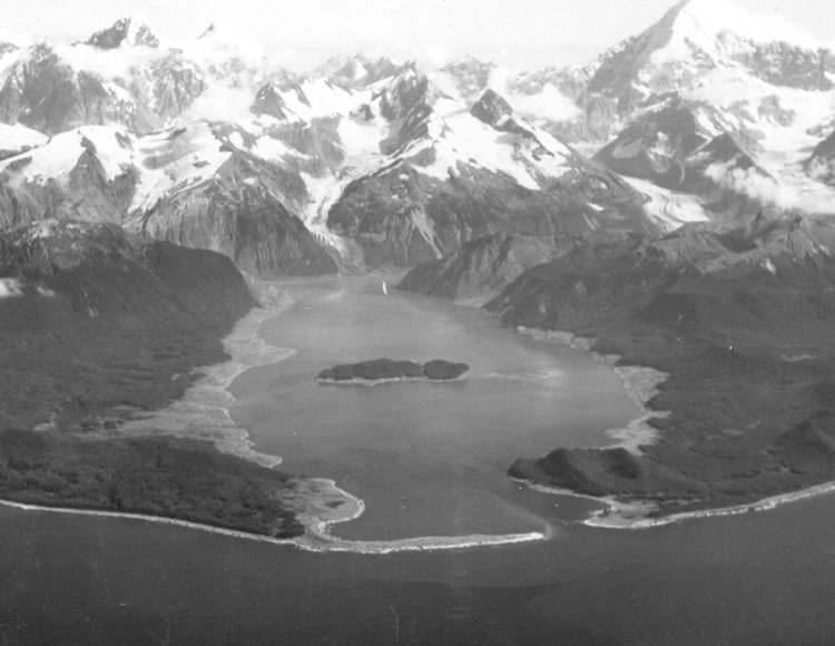
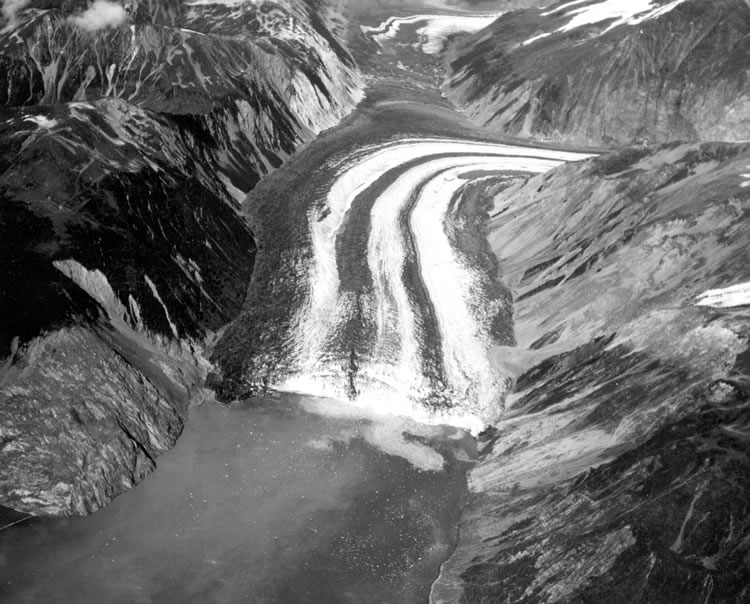
https://geology.com/records/biggest-tsunami.shtml
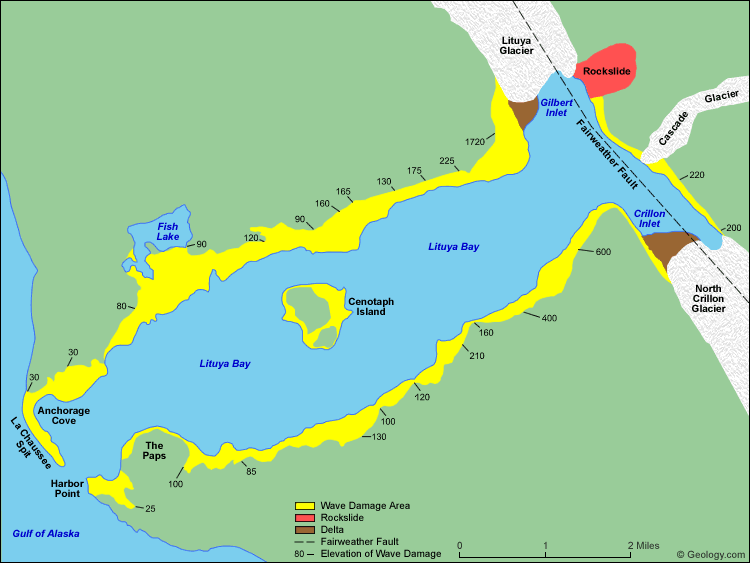


Quote:
The rockfall of July 9, 1958 occurred on steep cliffs above the northeast shore of Gilbert Inlet. It is marked on the map above in red. The rocks fell from an elevation of about 3000 feet (914 meters). The impact of 40 million cubic yards (30.6 million cubic meters) of rock hitting the water produced a local tsunami that swept the entire length of the Lituya Bay and over the La Chaussee Spit. This wave stripped all vegetation and soil from along the edges of the bay. This damaged area is shown in yellow on the map above. The numbers are elevations (in feet) of the upper edge of the wave damage area and represent the approximate elevation of the wave as it traveled through the bay. Map redrawn from data included in United States Geological Survey Professional Paper 354-C.

Eyewitness Accounts from Survivors
(As reported by Don J. Miller in United States Geological Survey Professional Paper 354-C, Giant Waves in Lituya Bay, Alaska, 1960)

Account of Howard G. Ulrich

Mr. Ulrich and his 7-year-old son, on the Edrie, entered Lituya Bay about 8:00 p.m. and anchored in about 5 fathoms of water in a small cove on the south shore. Ulrich was awakened by the violent rocking of the boat, noted the time, and went on deck to watch the effects of the earthquake-described as violent shaking and heaving, followed by avalanching in the mountains at the head of the bay. An estimated 2 1/2 minutes after the earthquake was first felt a deafening crash was heard at the head of the bay. According to Ulrich,

"The wave definitely started in Gilbert Inlet, just before the end of the quake. It was not a wave at first. It was like an explosion, or a glacier sluff. The wave came out of the lower part, and looked like the smallest part of the whole thing. The wave did not go up 1,800 feet, the water splashed there."

Ulrich continued to watch the progress of the wave until it reached his boat about 2 1/2 to 3 minutes after it was first sighted. Being unable to get the anchor loose, he let out all of the chain (about 40 fathoms) and started the engine. Midway between the head of the bay and Cenotaph Island the wave appeared to be a straight wall of water possibly 100 feet high, extending from shore to shore. The wave was breaking as it came around the north side of the island, but on the south side it had a smooth, even crest. As it approached the Edrie the wave front appeared very steep, and 50 to 75 feet high. No lowering or other disturbance of the water around the boat, other than vibration due to the earthquake, was noticed before the wave arrived. The anchor chain snapped as the boat rose with the wave. The boat was carried toward and probably over the south shore, and then, in the backwash, toward the center of the bay. The wave crest seemed to be only 25 to 50 feet wide, and the back slope less steep than the front.

After the giant wave passed the water surface returned to about normal level, but was very turbulent, with much sloshing back and forth from shore to shore and with steep, sharp waves up to 20 feet high. These waves, however, did not show any definite movement either toward the head or the mouth of the bay. After 25 to 30 minutes the bay became calm, although floating logs covered the water near the shores and were moving out toward the center and the entrance. After the first giant wave passed Ulrich managed to keep the boat under control, and went out the entrance at 11:00 p.m. on what seemed to be a normal ebb flow.


Account of William A. Swanson

Mr. and Mrs. Swanson on the Badger entered Lituya Bay about 9:00 p.m., first going in as far as Cenotaph Island and then returning to Anchorage Cove on the north shore near the entrance, to anchor in about 4 fathoms of water. Mr. Swanson was wakened by violent vibration of the boat, and noted the time on the clock in the pilot house. A little more than a minute after the shaking was first felt, but probably before the end of the earthquake, Swanson looked toward the head of the bay, past the north end of Cenotaph Island and saw what he thought to be the Lituya Glacier, which had "risen in the air and moved forward so it was in sight. * * * It seemed to be solid, but was jumping and shaking * * * Big cakes of ice were falling off the face of it and down into the water." After a little while "the glacier dropped back out of sight and there was a big wall of water going over the point" (the spur southwest of Gilbert Inlet). Swanson next noticed the wave climb up on the south shore near Mudslide Creek. As the wave passed Cenotaph Island it seemed to be about 50 feet high near the center of the bay and to slope up toward the sides. It passed the island about 2 1/2 minutes after it was first sighted, and reached the Badger about 1 1/2 minutes later. No lowering or other disturbance of the water around the boat was noticed before the wave arrived.

The Badger, still at anchor, was lifted up by the wave and carried across La Chaussee Spit, riding stern first just below the crest of the wave, like a surfboard. Swanson looked down on the trees growing on the spit, and believes that he was about 2 boat lengths (more than 80 feet) above their tops. The wave crest broke just outside the spit and the boat hit bottom and foundered some distance from the shore. Looking back 3 to 4 minutes after the boat hit bottom Swanson saw water pouring over the spit, carrying logs and other debris. He does not know whether this was a continuation of the wave that carried the boat over the spit or a second wave. Mr. and Mrs. Swanson abandoned their boat in a small skiff, and were picked up by another fishing boat about 2 hours later.


Quote:
Lituya Bay a few weeks after the 1958 tsunami. The areas of destroyed forest along the shorelines are clearly recognizable as the light areas rimming the bay. A fishing boat anchored in the cove at lower left was carried over the spit in the foreground; a boat under way near the entrance was sunk; and a third boat, anchored near the lower right, rode out the wave. Photo by D.J. Miller, United States Geological Survey.


Quote:
Photo looking down the Fairweather Fault Trench at the head of Lituya Bay. The front of Lituya Glacier with lateral and medial moraines is seen terminating in Gilbert Inlet. The cliff where the rockslide originated is on the right side of Gilbert Inlet. The opposite valley wall on the left side of Gilbert Inlet received the full force of the big wave, stripping it of soil and trees. Photo by D.J. Miller, United States Geological Survey.


Quote:
The spur of land between Gilbert Inlet and Lituya Bay that received the full force of the wave. Trees and soil were stripped away to an elevation of 1720 feet (524 meters) above the surface of Lituya Bay. Photo by D.J. Miller, United States Geological Survey.


Quote:
Wave damage on the south shore of Lituya Bay, from Harbor Point to La Chaussee Spit, southwest of Crillon Inlet. Tree trunks can be seen in the water and tree stumps along the lower shoreline. This location is seven miles (11.3 kilometers) away from where the wave originated. Photo by D.J. Miller, United States Geological Survey.
__________________
Steve
'08 Boxster RS60 Spyder #0099/1960
- never named a car before, but this is Charlotte.
'88 targa SOLD 2004 - gone but not forgotten
Old 05-28-2020, 10:25 AM
  Pelican Parts Catalog | Tech Articles | Promos & Specials    Reply With Quote #11 (permalink)
Registered
 
craigster59's Avatar
 
Join Date: Aug 2004
Location: Gilbert, Az
Posts: 21,851
Garage
Quote:
Originally Posted by widebody911 View Post
Question: I don't see any rebar: is it just something you can't see at this scale, or is it not used in this application?
It was pretty much an earthen dam with some non-reinforced concrete supports.
Old 05-28-2020, 10:42 AM
  Pelican Parts Catalog | Tech Articles | Promos & Specials    Reply With Quote #12 (permalink)
Registered
 
varmint's Avatar
 
Join Date: Nov 2003
Location: secure undisclosed locationville
Posts: 24,381
used to ride there all the time. there were two story house size chunks of concrete scattered around the canyon. confused me until i heard the story.
__________________
1971 R75/5
2003 R1100S
2013 Ural Patrol
2023 R18
Old 05-28-2020, 12:10 PM
  Pelican Parts Catalog | Tech Articles | Promos & Specials    Reply With Quote #13 (permalink)
Registered
 
ckissick's Avatar
 
Join Date: Jan 2003
Location: the beach
Posts: 5,155
Quote:
Originally Posted by craigster59 View Post
It was pretty much an earthen dam with some non-reinforced concrete supports.
Actually, it was a concrete gravity dam with a bit of an arch dam component to it. No rebar, though.
__________________
Charlie
1966 912 Polo Red
1950 VW Bug
1983 VW Westfalia; 1989 VW Syncro Tristar Doka
Old 05-28-2020, 12:33 PM
  Pelican Parts Catalog | Tech Articles | Promos & Specials    Reply With Quote #14 (permalink)
AutoBahned
 
RWebb's Avatar
 
Join Date: Jul 2007
Location: Greater Metropolitan Nimrod, Orygun
Posts: 55,993
Garage
"huge wave over the top of dam" makes think of the dam busting "oil drum" munitions used by the Allies in WWII
Old 05-28-2020, 12:56 PM
  Pelican Parts Catalog | Tech Articles | Promos & Specials    Reply With Quote #15 (permalink)
Registered
 
ckissick's Avatar
 
Join Date: Jan 2003
Location: the beach
Posts: 5,155
And then there was the dam (two dams, actually) that didn't fail.

The Crystal Springs Dam, a concrete gravity dam, is located right next to the San Andreas Fault. It was built in 1888 and held up just fine during the 1906 earthquake, despite about 20 feet of offset of the fault.

It's sister dam in the two-reservoir system, an earthen berm dam built in 1868, actually crosses the fault. It was offset 20 feet in 1906 and did not fail. Someone knew what they were doing in the 1860s and 1880s.

https://en.wikipedia.org/wiki/Crystal_Springs_Dam
__________________
Charlie
1966 912 Polo Red
1950 VW Bug
1983 VW Westfalia; 1989 VW Syncro Tristar Doka
Old 05-28-2020, 11:32 PM
  Pelican Parts Catalog | Tech Articles | Promos & Specials    Reply With Quote #16 (permalink)
canna change law physics
 
red-beard's Avatar
 
Join Date: Jul 2000
Location: Houston, Tejas
Posts: 43,406
Garage
Quote:
Originally Posted by KNS View Post
I recall seeing a documentary on the Italian dam failure (can't remember where I saw it...). The US Army helped quite a bit with helicopter evacuations and patient transport.
They had this on an episode of "Engineering Disasters".
__________________
James
The pessimist complains about the wind; the optimist expects it to change; the engineer adjusts the sails.- William Arthur Ward (1921-1994)
Red-beard for President, 2020
Old 05-29-2020, 04:50 AM
  Pelican Parts Catalog | Tech Articles | Promos & Specials    Reply With Quote #17 (permalink)
Registered
 
vash's Avatar
 
Join Date: Sep 2003
Location: in my mind.
Posts: 32,096
Garage
Send a message via AIM to vash
no rebar in that concrete?

__________________
poof! gone
Old 05-29-2020, 10:13 AM
  Pelican Parts Catalog | Tech Articles | Promos & Specials    Reply With Quote #18 (permalink)
 
Reply


All times are GMT -8. The time now is 12:41 PM.


Powered by vBulletin® Version 3.8.7
Copyright ©2000 - 2025, vBulletin Solutions, Inc.
Search Engine Optimization by vBSEO 3.6.0
Copyright 2025 Pelican Parts, LLC - Posts may be archived for display on the Pelican Parts Website -    DMCA Registered Agent Contact Page
 

DTO Garage Plus vBulletin Plugins by Drive Thru Online, Inc.